

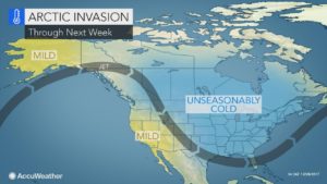
You might be freezing right now, but rest assured that a break from the frigid temperatures is on its way for much of Canada.
According to Brett Anderson, senior meteorologist with AccuWeather, temperatures will start to warm up early next week.
“There’s going to be relief in all of southern Canada next week,” Anderson said. “Temperatures start to warm up nicely.”
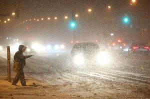
Most of the country has been experiencing unprecedented cold temperatures from the recent “polar vortex” – a biting cold weather phenomenon we were introduced to as it made its way through North America late last year – and Environment Canada has been regularly issuing extreme cold warnings across the bulk of the country since.
Toronto has hit record-breaking temperatures past -20 C, feeling closer to -40 C with the wind chill, demolishing a record that was establishing in 1959. This cold weather is expected to continue into the weekend with temperatures in Toronto being forecasted at -22 C on Saturday night and outlying areas will likely experience even colder temperatures around -30 C.
“The worst of the cold is probably going to be through Saturday, Saturday night,” Anderson said.
AccuWeather’s senior meteorologist does identify that Saturday is likely the end of this extended cold snap, with temperatures expected to warm up on Sunday and into Monday.
“Monday we’re looking at temperatures around 2 C for a high, that’s normal,” Anderson said for the Toronto area. “Only getting down to about -5 C at night on Monday.”
Some snow is expected to accompany this milder Monday weather in the region.
“We’re looking at potential for some snow coming across southern, eastern Ontario later Sunday night and into Monday,” Anderson said. “Not a big storm but something that could bring 2 to 8 cm.”
If temperatures hovering closer to 0 C still isn’t warm enough for your liking, look out for above normal temperatures around January 20, 2017.
“By the 18th, 19th, 20th, the core of that arctic air is going to shift to the other side of the pole over Siberia and usually when that happens, you tend to see a significant warm up across North America,” Anderson said. “That’s what we think’s going to happen.”
Although milder temperatures are on the way for the eastern portion of the country, Mother Nature is bringing the cold to British Columbia next week. Anderson expected that temperatures will average around 5 to 10 C below normal from northern B.C. to southern Manitoba.